Our goal is to map the entire remnant at the highest attainable spatial
resolution that can be attained with the ROSAT-HRI. Achieving this
ambition is not simple, because the resolution is limited by the
intrinsic instrumental properties and photon counting statistics. The
large range of surface brightness allows us the luxury of mapping the
brightest regions at full HRI resolution, but forces us
to seek a compromise between effective resolution and observing time in
the dimmest regions. To give a concrete example, the surface brightness
observed with the ROSAT yields a count rate in a ![]() pixel
(essentially an HRI resolution element) of
pixel
(essentially an HRI resolution element) of ![]() . For the brightest regions along the
shell (within
. For the brightest regions along the
shell (within ![]() of the highest surface brightness) a
of the highest surface brightness) a ![]() exposure will net 15 counts (vs. 0.4 background counts).
It would take
exposure will net 15 counts (vs. 0.4 background counts).
It would take ![]() to obtain a similar number of counts in
the interior. We therefore adopted the following observing strategy:
to obtain a similar number of counts in
the interior. We therefore adopted the following observing strategy:
Fig.1 shows the locations of the survey pointings on the Einstein IPC map.
This project is a collaborative project
between U.S. and German observers because of the large total observing
time required to complete this program ( ![]() s). As a joint project,
it displays the level of bipartisan collaboration that has been the
hallmark of the ROSAT program since its inception, and in this spirit
we have divided the Cygnus Loop fields equally among the two national
TAC's. It is our intention to carry out this program for the community
at large, therefore we have waived our proprietary rights so
as to grant immediate access to the data.
s). As a joint project,
it displays the level of bipartisan collaboration that has been the
hallmark of the ROSAT program since its inception, and in this spirit
we have divided the Cygnus Loop fields equally among the two national
TAC's. It is our intention to carry out this program for the community
at large, therefore we have waived our proprietary rights so
as to grant immediate access to the data.
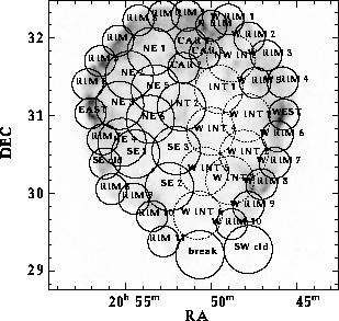
Figure: Scheduled and requested Cygnus Loop ROSAT-HRI pointings
superimposed on the Einstein IPC image (Seward 1990).
Circle size indicates the useful field of view
and is proportional to integration time. Solid
circled fields have been observed or scheduled;
dashed circles are the AO7 request.